
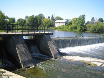
 Your on-water adventure starts below the Eric T. Casselman Dam in Chesterville. Access the Dam on William Street at St. Mary’s School and follow the path along the fence to the River’s edge.
Water levels can be low during the summer and towing your boat may be necessary for up to 4 km. The waters further downstream are easy to navigate and lead you to Crysler. Note: Beware of the orange and white buoys marking the approaching dam.
Take your canoe or kayak out of the water at the Crysler Village Park on the west side of the River, and portage about 0.5 km to the former site of St. John’s Anglican Church.
Access the River by portaging along Second Street; turning left onto Queen Street; crossing the bridge; and turning right on Charles Street. A gravel path leads down to the River where water levels are typically good year round from Crysler to Casselman. Make a stop at St-Albert Conservation Area, which offers privies and scenic, farmland views. Nearby, enjoy the St-Albert Co-Op Cheese Factory’s famously squeaky curds.
Downstream of St-Albert, you will reach High Falls Conservation Area in Casselman. Enjoy a picnic in the parkland on either side of the River’s edge while taking views of century-old dam ruins. Privies and garbage cans are available for your convenience. Orange and white buoys mark an approaching dam downstream, and you will need to remove your watercraft at the boat launch.
Starting point: William Street, Chesterville
Ending point: County Road 3, Casselman
Estimated distance: 38 km (C-D on map)
Estimated time: 9.5 hours