
A twenty-kilometre section of the South Nation River within The Nation Municipality between the Village of Casselman and the former Hamlet of Lemieux is subject to large scale retrogressive landslides.
This area – identified as the Casselman to Lemieux Potential Retrogressive Landslide Area (the “PRLA”) – has been the subject of decades of geotechnical studies.
Geotechnical and historical data conclude that a major retrogressive landslide could occur in the PRLA at any time, endangering lives and resulting in the loss of buildings, infrastructure, and land.
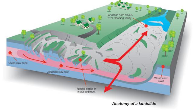
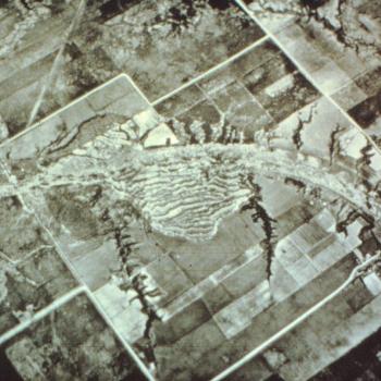
Since 1850, five large retrogressive landslides have been documented between Casselman and Lemieux and the scars of an additional seven or eight older retrogressive landslides are evidence that the process has been ongoing for a considerable time. The two most recent major retrogressive landslides occurred in 1971 and 1993.
1971 South Nation River Landslide
On May 16, 1971, 4.5 km upstream of the hamlet of Lemieux, a large clay flow destroyed 28 hectares of farmland. The landslide left a scar 750 m wide with a headward retrogression of 450 m. About 6 million cubic metres of sediment flowed into the South Nation River, damming the river for months. Just twelve days prior, a sensitive clay flow in St. Jean Vianney, Quebec took 31 lives.
 Click here to access the landslide event photo gallery.
1993 Lemieux Landslide
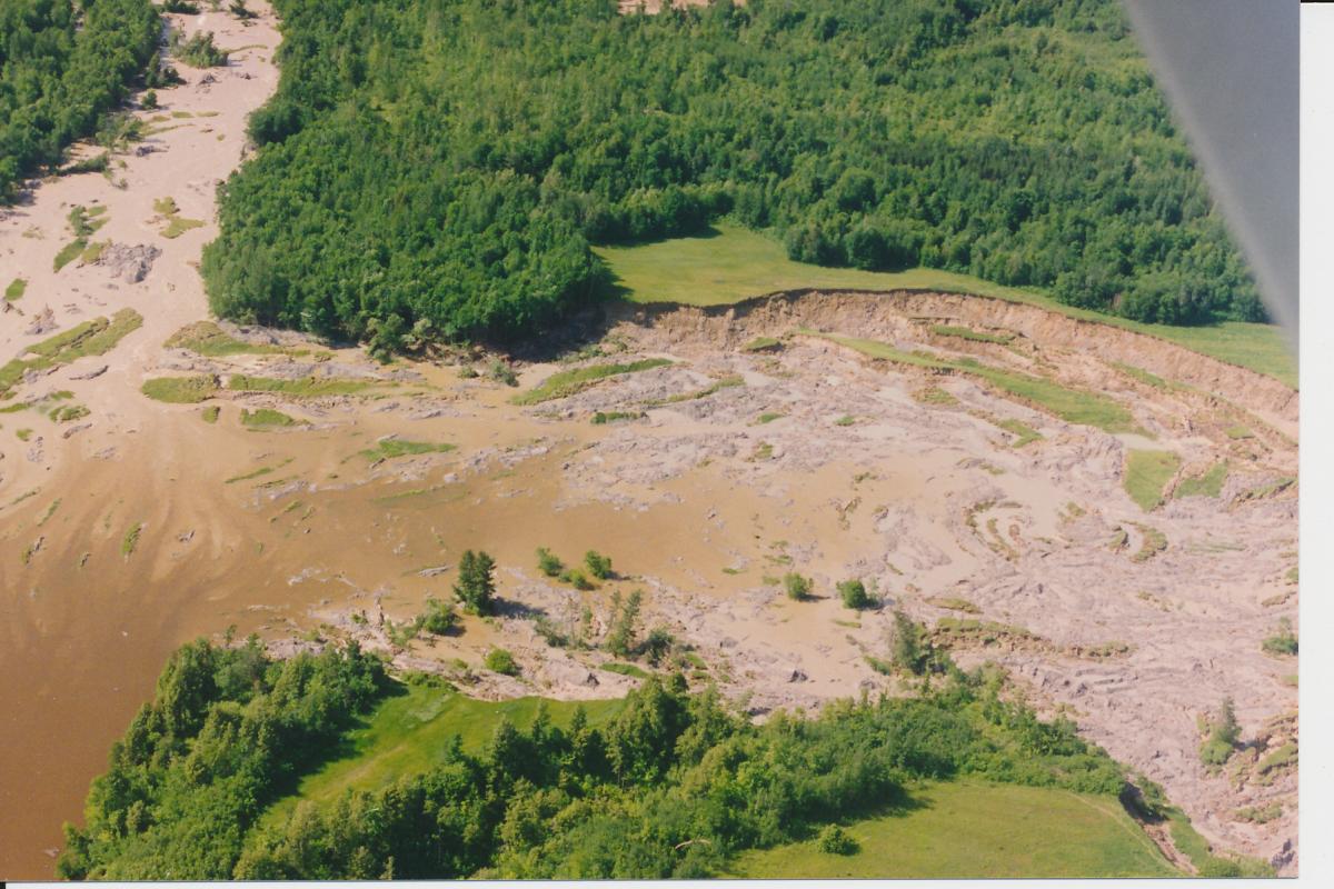
The most recent landslide occurred on June 20, 1993, five hundred metres from the main street of the former Hamlet of Lemieux. The failure involved 2.5 to 3.5 million cubic metres of sand, silt, and clay flowing into the South Nation Valley, inundating 3.3 km of the valley bottom and damming the South Nation River for four days. The landslide created a scar 320 m wide, 680 m in length, and 10 to 20 m deep.
Loss of life was avoided due, in part, to SNC who, with Ministry of Natural Resources funding and support, purchased 28 residential properties in Lemieux from willing sellers two years prior to the 1993 Landslide.
 Click here to access the landslide event photo gallery.
Seguinbourg Berm
The Seguinbourg Development Area consists of a residential area located about two kilometres north of Casselman. The site extends about 1.8 km along the northeast bank of the South Nation River.
A 1982 study of the South Nation River by the Ministry of Natural Resources (“MNR”) indicated that the Seguinbourg Development Area could be within a retrogressive landslide area. To mitigate risk to people and property, SNC undertook the construction of a rock berm below the development area.
The Seguinbourg Berm was constructed between 1987 and 1990 at a cost of $750,000 shared between SNC and MNR grants. The Berm stabilized 1,800 m of the riverbank, protecting it from toe erosion.
As of 2019, the Seguinbourg Berm mitigates the risk of potential retrogressive landslides for more than 50 residential properties in The Nation Municipality.
RESOURCES:
CASSELMAN - LEMIEUX POTENTIAL RETROGRESSIVE LANDSLIDE AREA MAP
CASSELMAN - LEMIEUX POTENTIAL RETROGRESSIVE LANDSLIDE OVERVIEW MAP
PUBLIC GEOPORTAL
TVO DOCUMENTARY LEMIEUX LANDSLIDE
RISSA LANDSLIDE DOCUMENTARY
Reports:
- The Lemieux Landslide of June 20, 1993, South Nation Valley, southeastern Ontario *Note: SNC did not expropriate these properties but purchased them at market value from willing sellers*
- Description of the landslide that occurred at Lemieux on June 20, 1993 and the impacts on the South Nation River
- Summary of the history of landslides along the South Nation River, and a description of the sensitive clay (leda clay) and its potential for landslides along the South Nation River
- Description of sensitive clay (leda clay) along the South Nation River, a summary of retrogressive landslides and summary of a field program along the South Nation River to determine slope stability
- Description of the landslide that occurred along the South Nation River on May 16, 1971
Further Resources: