Français

Some Conservation Areas Closed: Please Respect Direction of Health Authorities

South Nation Conservation (SNC) is committed to supporting municipalities, partners and people as the Coronavirus (COVID-19) Pandemic unfolds.

In accordance with the Government of Ontario’s Emergency Order on March 31, all outdoor recreational amenities in the province are closed.

The order does not apply to green spaces including parks, trails, and Conservation Areas. SNC has closed facilities with its municipal partners and some Conservation Areas.

English

Flood Watch — Lower Ottawa River

April 9, 2020 — A Flood Watch is being issued for areas along the Lower Ottawa River. Water levels and flows from Arnprior to Hawkesbury continue to rise gradually due to on-going snowmelt in the central and northern portions of the Ottawa River basin.

On Monday a spring storm is expected to bring above average temperatures and a significant amount of rainfall. Minor flood levels may be exceeded in low-lying, flood prone areas depending on the temperatures and precipitation received.

English

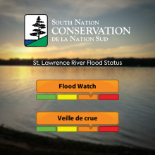
WATERSHED CONDITIONS STATEMENT: Flood Outlook – St. Lawrence River (UPDATE #3)

This Statement is an update to the Flood Outlook Statement issued on March 27h, 2020.

Weather Forecast:
Scattered showers may occur across Eastern Ontario next week, but no significant rain event is in the forecast at this time.

Environmental Conditions:
According to the International Lake Ontario – St. Lawrence River Board, although no major weather event is in the current forecast, Lake Ontario’s water levels are above average for this time of year and will likely continue rising slightly next week.

English

WATERSHED CONDITIONS STATEMENT: Water Safety

Weather Forecast:
Environment Canada is forecasting rainfall of 25 to 30 mm on Sunday, March 29th into Monday, March 30th.

Environmental Conditions:
Water levels across the watershed are normal for this time of year but are expected to increase in the coming days.

Risks:
Rainfall is likely to produce high water levels and possible nuisance flooding in low-lying areas across the watershed.

English

WATERSHED CONDITIONS STATEMENT: Flood Outlook – St. Lawrence River (UPDATE #2)

This statement is an update to the Flood Outlook Statement issued on March 20th, 2020.

Weather Forecast:
Thunderstorms are possible across Eastern Ontario on Sunday, March 29th, with total rainfall amounts of up to 25 mm.

Environmental Conditions:
According to the International Lake Ontario – St. Lawrence River Board, Lake Ontario’s water levels are above average for this time of year and will continue to rise next week as a result of Sunday’s weather forecast.

English

WATERSHED CONDITIONS STATEMENT: Flood Outlook – St. Lawrence River (UPDATE)

This statement is an update to the Flood Outlook Statement issued on March 13th, 2020.

Weather Forecast:
According to Environment Canada, thunderstorms are possible across Eastern Ontario starting on Friday, March 20th, with total rainfall amounts of 10 to 20 mm. Additional rainfall is possible in some areas depending on thunderstorm activity.

Some thunderstorms may become severe along the St. Lawrence River causing wind gusts upwards of 90 to 105 km/h.

English

WATERSHED CONDITIONS STATEMENT: Flood Outlook – St. Lawrence River

March 13th, 2020

Weather Forecast:
Environment Canada is forecasting a freeze-thaw cycle for the next 7 days as high temperatures between 2 to 8°C are expected until Thursday, March 19th. Forecasted rainfall amounts of 15 to 25 mm are expected to end today and no significant precipitation is in the forecast for the next week.

There will be strong winds of 50 to 80 km/h today and Saturday, March 14th, and 30 to 50 km/h winds on Sunday, March 15th.

English