
Monitoring Watershed Conditions a Year-Round Priority
Protecting people and property in the watershed from the effects of flooding, landslides and drought is top of mind for South Nation Conservation (SNC) when it monitors water quality and quantity throughout its jurisdiction in Eastern Ontario.
Environmental monitoring and reporting support on-the-ground restoration projects and landowner stewardship, conservation lands management and education, development review and flood forecasting and warning programs.
“Our frontline team monitors watershed health in the field to supplement information from our Climate Stations that guide our computer models and support local flood forecasting. While flood season is typically in the spring, we know that flooding can occur at anytime,” explained Sandra Mancini, SNC Engineering Lead. “That’s why we monitor levels and flows everyday and continue to operate our flood control structures when required.”
SNC’s Flood Forecasting and Warning Team reviews and analyses water resource data daily to ensure timely notification of flood and drought potential.
In partnership with the Province of Ontario, SNC maintains a network of stream gauges, rain gauges, and snow and ice survey sites within the watershed. SNC also conducts baseline water quality monitoring with the Ottawa Conservation Authority Partners (Rideau Valley and Mississippi Valley) on behalf of the City of Ottawa.
“We analyze the data from stream and rain gauges at our Climate Stations daily to support programs like Flood Forecasting and Warning, Low Water Response, water control structure management, and shoreline erosion repair,” explained Mancini.
Thanks to Federal Government support provided to SNC in recent years, the agency has also created a real-time watershed model, that was developed through an agreement with IBM, that incorporates all the watershed monitoring data available from SNC and government sources, including groundwater and surface water data, weather conditions, precipitation, and temperature to predict the movement of water within the region.
Information collected at SNC Climate Stations can also be accessed directly on their website (nation.on.ca) by clicking the “View Water Levels” tab on their website homepage.
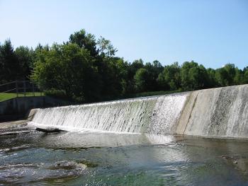
SNC owns, operates, and maintains seven water control structures and has undertaken four flood control channelization projects throughout the watershed. This infrastructure serves purposes such as flood control, erosion control, low flow augmentation, water supply, recreation, and protection of fish and wildlife habitat.
FOR MORE INFORMATION: Shannon Gutoskie, Communications Specialist, 1-877-984-2948, sgutoskie@nation.on.ca