
Public Invited to Open Houses on Natural Hazard Mapping in Rural East Ottawa
South Nation Conservation (SNC) invites residents in the City of Ottawa’s rural east end to attend public open houses taking place on January 29th at the Kenmore Community Centre in Kenmore and on January 30th at École élémentaire catholique Saint-Guillaume in Vars to view and comment on new natural hazard maps for their areas.
Updated floodplain and erosion hazard maps were developed for the areas of South Castor River, from Victoria Street to Springhill Road, and Shaw’s Creek, from Perrault Road to Burton Road.
Natural hazard maps are used by the City and SNC when updating official plans and zoning schedules, and in reviewing development applications to protect people and property from natural hazards and guide sustainable development. SNC updates these maps on behalf of its partner municipalities, when requested.
“The ultimate goal of the mapping is to help ensure safe development,” said Sandra Mancini, SNC’s Engineering Lead. “It’s all about keeping people and property safe.”
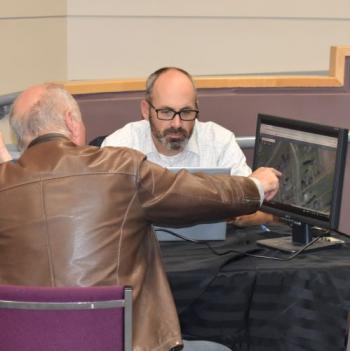
Residents will have the opportunity to sit down one-on-one with SNC staff at the open houses to review the new natural hazard maps and ask questions. Residents with affected property received letters from SNC before the mapping work began, and again this week to invite them to the open house.
“We are particularly interested in historical information that residents may be able to provide for these watercourses,” said Mancini. “Feel free to bring along photos, news clippings, and anecdotal stories to compare to the maps,” she added.
SNC also works closely with its partner municipalities to help provide advance notice of flooding to reduce risk to life and property damage through the Flood Forecasting and Warning Program.
The public open house for updated natural hazard maps along South Castor River will be taking place from 6:30 pm to 8:30 pm on Wednesday, January29th at the Kenmore Community Centre (3246 York’s Corners Road, Kenmore).
The public open house for updated natural hazard maps along Shaw’s Creek will be taking place from 6:30 pm to 8:30 pm on Thursday, January 30th at École élémentaire catholique
Saint-Guillaume (5750 Buckland Road, Vars).
For more information, please visit www.nation.on.ca or call 1-877-984-2948.
###