
 The Ontario Ministry of Natural Resources identifies areas of land and water that represent significant, natural features, and decides which have the highest value for conservation. The Nash Creek subwatershed in South Dundas contains many habitats that the MNR recognizes as an Area of Natural Scientific Interest and a Provincially Significant Wetland.
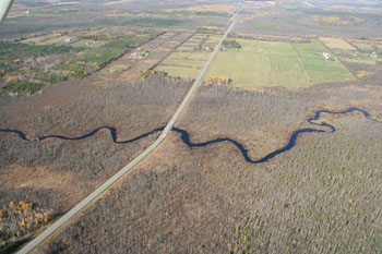
Nash Creek flows from wetland headwaters, south through tracts of forest and agricultural land, until it empties into the St. Lawrence River at Morrisburg. It drains an area of land about 74 km2.
Nash Creek is formerly known as Hoasic Creek; the official name change occured on September 29, 2015.
Under its former name, a committee called the Hoasic Creek Committee, comprising landowners in the Creek's subwatershed, partnered with SNC to address concerns about drainage and the local environment.
The 2010 Hoasic Creek Subwatershed Plan serves to rehabilitate, protect, and enhance the natural features, functions, and health of the subwatershed. At the same time, the Plan accommodates recreational activity and enterprise. As part of these goals, the partners identify the following four objectives:
- Address flooding and land drainage issues;
- Maintain or improve surface water quality for aquatic life and recreational purposes;
- Protect and enhance natural heritage features and functions in the subwatershed; and
- Encourage landowner stewardship opportunities.